During my university career I wrote three theses, and completed various other pieces of work. They are available for download on this page.
If you're doing any similar work as part of your University of Southampton degree then please don't bother copying these reports. The university uses anti-plagiarism software, and you will be caught and punished.
PhD thesis
My PhD thesis was entitled Developing a novel method to retrieve high spatial resolution Aerosol Optical
Thickness (AOT) from satellite data and was completed at the University of Southampton in February 2015. My supervisors
were Prof E. J. Milton, Dr J. M. Nield and Dr J. Noble. It won the RSPSoc PhD Prize.
It is available for download here.
MSc thesis
My PhD was done through a Doctoral Training Centre, so I did a year of Masters level work before starting my main research.
As part of that first year I wrote a Masters-level thesis, although I didn't actually gain a MSc qualification.
My thesis was entitled “Can a single cloud spoil the view?”:
Modelling the effect of an isolated cumulus
cloud on calculated surface solar irradiance and was completed at the University of Southampton in October 2011. My
supervisor was Prof E. J. Milton. It won the RSPSoc MSc
Prize.
It is available for download here.
Undergraduate thesis
My dissertation was entitled Automated Selection of Suitable Atmospheric Calibration Sites for Satellite Imagery, was
completed in 2010 and was supervised by Prof. E. J. Milton. It received a mark of 81% (the second highest mark in my
year). I wrote a conference paper based on my dissertation for presentation at RSPSoc 2010.
It is available for download here.
The RSPSoc conference paper is available here.

Investigation of The Relative Sensitivity of Drainage Basins to Climate Change in Semi-Arid and Humid-Temperate Environments
This piece of work was carried out for the GEOG2016 course Drainage Basin Geomorphology. It gained a mark of 90%, with a
comment from the lecturer saying that this was by far the best piece of work he had seen in five years of running the
course. It uses the WILSIM model to simulate climate change in two drainage basins: the River Tyne (North England) and
Walnut Gulch (Arizona).
It is available for download here.

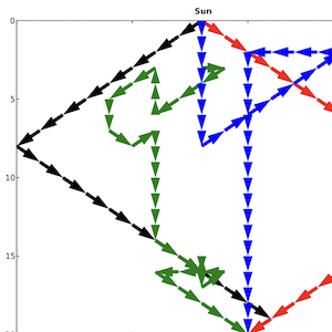
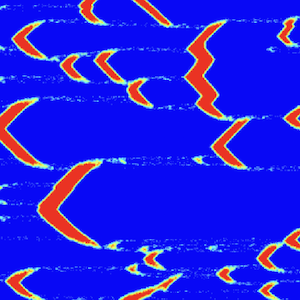
The Effect of Surface Moisture on Dunefield Self-Organisation
This piece of work was carried out for the GEOG3048 course Aeolian Systems and Geomorphic Modelling. It gained a mark of
86%. It uses the DECAL model to simulate changes in White Sands Dunefield (New Mexico) due to changes in surface
moisture. The self-organisation of the dunes in the model results was analysed using GIS-based Nearest Neighbour
Analysis.
It is available for download here.
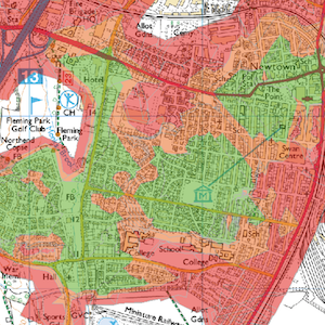
Access to Public Green Space in Eastleigh, Hampshire
This piece of work was carried out for the GEOG3006 course Advanced GIS. It gained a mark of 79%. It uses ArcGIS Network
Analyst tools along with Ordnance Survey ITN data to produce maps showing ease of access to public green space in an
area of Eastleigh. Statistics are also calculated to show how well Eastleigh fulfils national green space access
standards (for example ANGSt).
It is available for download here.